Peak-Parrisal Beceite Arani. not need to go to the Pyrenees to enjoy great mountain routes.
 |
| "Forest" on the Matarraña needle from Arani 1228m peak. |
From Beceite (Teruel) there is a paved road to the site of Parrisal. 660m altitude. We going up the river to a parking area. Nearby there are cave paintings. Follow the track to a picnic (Source right), a signal with an information panel on the left marks the beginning of TE-153 PR trail that climbs to the peak of 1228m Arani.
| |
| Estret of Parrisal. 05/14/1994 |
 |
| Parrisal Runway parking. |
The path is good and we were comfortably up to the Collado del Mas de la Balanguera 1030m (1 hour). Here we take the path to the right, it moves into the GR-8 by Muller Arani. Rises in the east of the crest, later approach to its edge (10 min. Giving us the option to climb a rocky elevation which is a magnificent viewpoint.) When we sense the proximity of the summit, we left the trail to climb onto the geodesic installed at the top. F-1228m. The views are extensive and our feet, we see a clump of needles at the bottom stone Matarraña in the river dug them Estret of Parrisal then will travel.
 |
| Peak Arc tectonic Arani. |
 |
| Arani Bluff 1228m. Beceite (Teruel). |
For the immediate path we reached a rock arch
next to the top. Later the path PR TE-153 is placid forest, we are walking by the southwest ridge.
The font
Mala (Cúpula-pozo. 2 hours) connect briefly with a track that goes east. After spending a hill, abandon it to the ruins of the Mas de Masana. This area is open to be an old area of \u200b\u200bwork. Descending towards the left bank of the ravine, where down a marked path. Met by the path, the Font of Teix in a 2'30-3 hours. We are at the head of Matarraña (If you went up the dry riverbed, we find two grooves. The second I call Millers Gorge, walked on the rise and fall on 15.09.1994, is quite interesting. I found no equip and currently do not know if equipped).
 |
| Another view of the rock arch. |
 |
Down the Matarraña | near the Estret. |
Beceite To return to only have to descend the river, being aware of paths that avoid the bed and facilitate the descent. Depending on the season find flow or not. At 1'15 hours more, we gouges (Gouges = Throat with Badina). It is a colossal gorge in summer is easy to navigate, but often have a long Badina of ice water to his chest. Freezes in winter and in summer can become dry.
 |
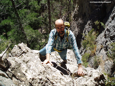
| Raising the Pas of Romeret in free (III °-III +). Via ferrata. |
we are to avoid the Romeret
Pas. It has now been equipped as a via ferrata (PD-), the rise of the right bank. Formerly hikers climbed clinging to chains and wire railings.
 |
| needles from the Romaret Pas. |
The Pas of Romeret offers a close view of the magnificent forest of needles. It's a vertical climb, the more mountaineers can do in free bonito III º. Higher up the canyon flanks to save, and luxury overlooking descends without difficulty (Previously also had a vertical piece with strings, in this aspect). We can only follow the tourist trail that leads from the Estret up the car, at 2'30 "3 hours from the Font of Teix. Total 6 hours.
 |
| Start Estret stroll. |
 |
| pathways of Parrisal. Window Rock. |
With children have two options:
The hiker along the river with no appreciable slope, avoiding the flooded areas by walkways. The safe ride that appeals to children and ends at the Estret, a large tributary canyon with waterfall and Badin to its input.
If scale, carrying material, after passing the Estret (Easy if dry), raise the Romeret Pas. Option
mountaineer is climbing the peak Arany returning by the same route (560 m level). Click for map
guidance. Another area with mountains all.


0 comments:
Post a Comment